Railroad Valley Playa
| Landsat 8 LandsatLook Image Path 40 Row 33 Acquired 25 May 2020 with ROI indicated | Landsat 8 LandsatLook Image Zoom of Railroad Valley Playa ROI |
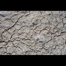
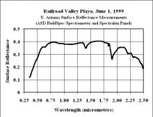
The Railroad Valley Playa site is a Committee on Earth Observation Satellites CEOS LANDNET site located in east central Nevada. The dry lakebed is comprised of compacted clay-rich lacustrine deposits forming a relatively smooth surface with no vegetation. The playa contains strong linear road features and oil drilling structures. It is 15 × 15 kilometers (km) in size, and at an altitude of 1435 meters. The atmospheric aerosol loading is generally low throughout much of the year, with an average aerosol optical depth of 0.060 at 550 nm [3]. The reflectance of the playa is generally greater than 0.3 and relatively flat spectrally with the exception of the Blue portion of the spectrum and an absorption feature in the Shortwave Infrared. Ground-based measurements of the directional reflectance characteristics of the playa show it to be nearly Lambertian out to view angles of 30 degrees for incident solar zenith angles, as observed from overpasses of Terra and Landsat [4].
Many studies have been performed to better characterize the Railroad Valley Playa site for vicarious calibration of different Earth Observing sensors. This site has been used widely for vicarious radiometric calibration and validation, including for Landsat 7 ETM+, Landsat 8 OLI, Moderate Resolution Imaging Spectroradiometer (MODIS), Medium Resolution Imaging Spectrometer (MERIS), Visible Infrared Imaging Radiometer Suite (VIIRS), Sentinel-2 MSI, etc. Moreover, the Railroad Valley Playa has great importance in the intercomparison and cross-calibration between two satellite sensors [2,4].
| Location (City, State, Country): |
Ely, Nevada, USA, North America
|
|---|---|
| Landsat WRS - 2 Path / Row: |
40/33
|
| Center Latitude (degrees): |
N 38.50
|
| Center Longitude (degrees): |
W 115.69
|
| CEOS Region of Interest |
N 38.5, W 115.69 Search this area in EarthExplorer (Landsat 8-9 Collection 2 Level-1) - date range, datasets, cloud cover and other criteria can be modified once initial results are returned |
| Size of Usable Area (km): |
15 x 15
|
| Altitude above sea level (meters): |
1,435
|
| Purpose: |
Radiometry
|
| Co-located Instrumented Networks: |
AERONET
RadCalNet
|
| Status: |
Active
|
- Shrestha, Mahesh, Dennis Helder, and Jon Christopherson. 2021. "DLR Earth Sensing Imaging Spectrometer (DESIS) Level 1 Product Evaluation Using RadCalNet Measurements" Remote Sensing 13, no. 12: 2420. https://doi.org/10.3390/rs13122420
- Tonooka, H.; Sakai, M.; Kumeta, A.; Nakau, K. In-Flight Radiometric Calibration of Compact Infrared Camera (CIRC) Instruments Onboard ALOS-2 Satellite and International Space Station. Remote Sens. 2020, 12, 58.
- Czapla-Myers, J., J. McCorkel, N. Anderson, and S. Biggar. 2017. "Earth-observing satellite intercomparison using the Radiometric Calibration Test Site at Railroad Valley." Journal of Applied Remote Sensing 12 (01): 1 [10.1117/1.jrs.12.012004].
- Myers, J. S., K. J. Thome, B. R. Cocilovo, J. T. McCorkel, and J. H. Buchanan. 2008. "Temporal, spectral, spatial study of the automated vicarious calibration test site at Railroad Valley, Nevada." Proceedings of SPIE Earth Observing Systems XIII 7081 (70810I): 9 pp. [10.1117/12.795551]
- Thome, K. J., J. T. McCorkel, and J. S. Czaple-Myers. 2008. "Inflight intersensor radiometric calibration using the reflectance-based method for Landsat-type sensors." ASPRS/Pecora 17.
Note: This information has been compiled by the USGS ECCOE Team, using the best sources currently known. Updates will be made as more information becomes available. Please contact eccoe@usgs.gov with any updates you would like to contribute.

![Tonooka, H.; Sakai, M.; Kumeta, A.; Nakau, K. In-Flight Radiometric Calibration of Compact Infrared Camera (CIRC) Instruments Onboard ALOS-2 Satellite and International Space Station. Remote Sens. 2020, 12, 58. Czapla-Myers, J., J. McCorkel, N. Anderson, and S. Biggar. 2017. "Earth-observing satellite intercomparison using the Radiometric Calibration Test Site at Railroad Valley." Journal of Applied Remote Sensing 12 (01): 1 [10.1117/1.jrs.12.012004]. Czapla-Myers, J. S., K. J. Thome, B. R. Cocilovo, J. T. McCorkel, and J. H. Buchanan. 2008. "Temporal, spectral, spatial study of the automated vicarious calibration test site at Railroad Valley, Nevada." Proceedings of SPIE Earth Observing Systems XIII 7081 (70810I): 9 pp. [10.1117/12.795551] Thome, K. J., J. T. McCorkel, and J. S. Czaple-Myers. 2008. "Inflight intersensor radiometric calibration using the reflectance-based method for Landsat-type sensors." ASPRS/Pecora 17. Tonooka, H.; Sakai, M.; Kumeta, A.; Nakau, K. In-Flight Radiometric Calibration of Compact Infrared Camera (CIRC) Instruments Onboard ALOS-2 Satellite and International Space Station. Remote Sens. 2020, 12, 58. Czapla-Myers, J., J. McCorkel, N. Anderson, and S. Biggar. 2017. "Earth-observing satellite intercomparison using the Radiometric Calibration Test Site at Railroad Valley." Journal of Applied Remote Sensing 12 (01): 1 [10.1117/1.jrs.12.012004]. Czapla-Myers, J. S., K. J. Thome, B. R. Cocilovo, J. T.](/apps/sites/default/files/styles/medium/public/test_site_images/RailroadValley-ground_600.jpg?itok=Y1kQWnpa)

